
Growing up in a small town just outside of Charleston, WV and being part of the "Bible Belt" it was always a running joke in my hometown between some of us there there were (literally speaking) twice as many churches as there were stoplights in our small town. With 6 Churches and 3 Stoplights (giving the town the 3rd stoplight is pretty generous as it's on the very edge of town) the math was easy. I wondered though, could I do it on a larger scale? A scale of a larger city? Or a whole State?
First trick would be to find the church data? I tried to think of religious databases then I realized I was approaching it was from the wrong direction. What is every church besides a religious organization...? A tax exempt organization! You know who likes taxes? The Federal Government! I knew that tax records are a matter of public record so a quick jaunt over to data.gov later and I'm swimming in tax exemption data!

I realized after I got this data that I'll do a future blog just about the non-profit data in the US, there is WAY more than I anticipated there being in that data. Luckily there is a tax exemption category for "churches" which includes churches, synagogues, mosques, and of course the Church of Scientology.
Next I wondered how in the world I was going to get the location of every single stoplight in KY. I hopped onto the Kentucky Transportation Cabinet and found their IT staff and shot one of them an email. BOOM! The county/latitude/longitude of EVERY SINGLE operating stoplight in the entire state! They were SUPER NICE about it too! I didn't even have to file an open records request! That is how you do public service ladies and gentlemen!
 |
| Thanks to the Kentucky Transportation Cabinet for making Kentucky a safer place to drive than this! |
Interestingly one of the things I came to notice really quickly was that several entire COUNTIES within Kentucky contained not ONE single stoplight!
Let's get into the data!
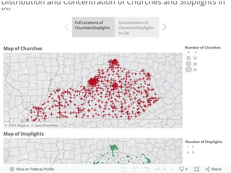
Where ARE all these things!? Check out this and click through the tabs to see where the locations and densities of churches and stoplights throughout Kentucky!
Next is a little Tableau Story showing the True/False status of "Small Towns" by Zip. Red represents small towns and blue are "Big City" towns. The next tab contains a more granular breakdown of "levels" of smallness. Finally is a chart showing "largest" to "smallest" using a difference over sum equation to normalize for the total number of churches/stoplights and keep it relative! Where does your hometown or birthplace fall!?
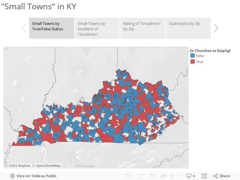
Ultimately what it all boils down to is that there are 504 zip codes with relevant data in the state of Kentucky and of those 185 are "big towns" in Kentucky and 319 are "small towns".
I know this data may not seem like much but it's been a LONG time in preparation and presentation. As always if you have any questions or anything hit me up on twitter at @wjking0!
P.S. This is the first in what I'm going to call my #1YearOfViz where I'm going to try to do a visualization EVERY SINGLE WEEK. I can't promise I'll always publish on the same day of the week or time but right now I'm looking at either Mondays or Wednesdays as my "publish days". If anyone knows any newspaper contacts or data journalism contacts that are looking for fun data related news stories have them tune in and get in touch! Also if you have any suggestions or thoughts on what you'd like to see over the next 52 weeks of viz give me a shout or leave a comment below!
No comments:
Post a Comment